The FlySight is currently the only GPS supported by gSwoop. If you have another GPS you would like to try send me an email.
To collect a swoop track turn on your GPS one minute before boarding the airplane and turn it off after you have landed your parachute and (optionally) walked back to your estimated touchdown point. Note that there are several things under your control that will impact the quality of your GPS data. Review the list below if your plots look noisy, speeds are erratic, or your side view plot makes it appear as if you swooped underground.
GPS configuration:
The Flysight GPS uses different models for different types of motion.
This is specified in the config.txt file located on your GPS. Set "Model" to
"Airborne with < 2 G acceleration". Set "Rate" to "200" (for 5Hz sampling)
or "100" (for 10Hz sampling if your GPS and firmware support this mode).
GPS mounting location:
The best place to mount your GPS is the top rear of your helmet. Also try to
keep the GPS as far as possible from electronic devices. Proximity to a GoPro
camera has been observed to cause erratic GPS data. You may have to experiment
to find what mounting location works best.
Almanac data acquisition:
At the beginning of the day (or before your first swoop) you should turn on your
GPS and leave it with a clear view of the sky for at least 15 minutes. This will
give it a chance to download the almanac data from all visible satellites.
Ephemeris data acquisition:
Your GPS needs at least 30 seconds before every swoop to collect the ephemeris
data from the satellites. During this time your GPS needs a clear view of the
sky. The inside of an airplane is not a good place for this! That is why you
should turn on your GPS before boarding the plane.
It takes about ten minutes to collect the gate location track needed by gSwoop to create a reference frame for your plots. Before you begin you must let the GPS acquire the almanac data as described above. Then follow the steps below. Stay as close as possible to the edge of the pond at all times if you want to include the pond perimeter in the overhead plot.
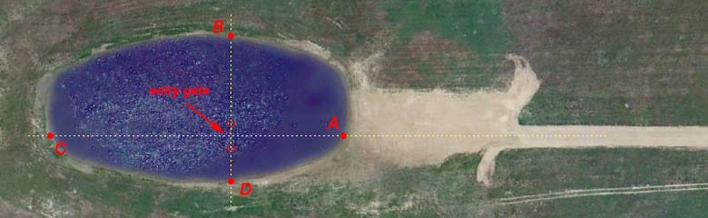
1) Walk to point A, hold the GPS at waist level, and turn on the GPS.
Stand still for 45 seconds.
2) Walk to point B and stand still for 45 seconds.
3) Walk to point C and stand still for 45 seconds.
4) Walk to point D and stand still for 45 seconds.
5) Walk to point A and stand still for 45 seconds.
6) Walk to the center of the speed exit gate and
stand still for 45 seconds (optional).
7) Turn off the GPS.